(LAist) It’s one of the biggest days of the year for the ecologically minded.
Thousands of volunteers across Southern California will come together on the morning of Saturday, Sept. 21, for the annual California Coastal Cleanup Day.
Last year, volunteers removed 376,308 pounds of trash from Cali beaches and waterways across the state, according to the California Coastal Commission, including 10 tons of debris in Los Angeles County and 12 tons in once filthy Orange County.
The cleanup provides insights into what’s being thrown away in Southern California or, more accurately, what’s being littered. Cigarette butts are the most commonly found item, though plastics and Styrofoam are becoming more common, according to the nonprofit Heal the Bay.
We've got a tropical blond surfer reputation
That’s despite the state’s efforts to cut back on the use of these items. In case anyone is wondering, those new rules are still being phased in as of this year.
If volunteers can’t make it to the beach but still want to help, consider volunteering at one of the inland cleanup sites listed below, because those “No dumping, Drains to ocean” signs on storm drains aren’t lying.
Today wasn't really convenient, so there are other options:
Heal The Bay
Heal has relaunched their monthly Nothin' But Sand clean-up events, which happen on the third Saturday of every month. By the way, the organization expects to cross 2 million pounds [2,000 lbs. is one ton] of trash picked up over the 35 years it's been managing Coastal Cleanup Day for L.A. County.
How to sign up
Some organizers just want volunteers to show up and help out, no sign up required — and beachgoers can always pick up trash wherever, whether or not it’s at one of these official sites.
However, others are requesting that volunteers register in advance to get an accurate headcount. A few of the more hands-on cleanup sites require boats or other special equipment.
To find more information for each site, including contact information and signup details, find it on THIS MAP from the California Coastal Commission.
Today is World Dolphin Day. Of course, we don't have to worry in the States because we worship this sea mammal on April 14th on NATIONAL DOLPHIN DAY each year when we recognize the social and intelligent mammals of the sea.
#NationalDolphinDay
Hey, Baby, come here often? - I'm a bird.
Dolphins are cetacean mammals that are related to whales and porpoises (and orcas or killer "whales" are actually giant dolphins). They range in size from 4 feet to up to 30 feet; dolphins are among almost forty species in 17 genera.
Found worldwide, they prefer the shallower seas of the continental shelves.
As predatory carnivores, their diet consists of mostly fish and squid.
[But they will rape and take a nip out of a human, smothering swimmers, taking them down to the seafloor to drown and/or penetrate, as was recently witnessed in Japan in gang rapes of swimmers at the beach by juvenile pods. They can get awful "friendly" in Hawaii, too, and jealous once they bond to a human. Others better watch out, and that human better watch out. Oh, Flipper, so named because they can flip out.]
(Motech) June 15, 2024: It’s been 30 years, and we are still plagued by what happened to these children. They witnessed something that forever changed the course of their lives. Some are still haunted by the sight of what they saw, and no amount of therapy can make it all go away. On Sept. 16, 1994, just outside of the small region of Ruwa, Zimbabwe, 62 children at a once prestigious school named Ariel said they saw one or more silver aircraft (flying saucers) descend from the sky and land on a field near their wealthy school. Despite critics, the children stand by what they saw and said.
ABOUT: Motech Channel shares everything about technology, space, and artificial intelligence, exploring cool advancements in science and innovation.
Consider subscribing to get a sneak peek of our future world.
Subscribe: bit.ly/3kTvUh6. #aliens#ufo #mystery
Cleo Abram, Huge If True, Oct. 2, 2023; Sheldon S., CC Liu (eds.), Wisdom Quarterly
The Ocean Is Deeper Than You Think. We Need Better Maps
(Cleo Abram) Why deep-sea maps are BAD (and how to fix that)... Our maps of the ocean are surprisingly bad! Google Maps makes it look like we know a lot, but we know less about the ocean floor than we do the surface of Mars.
And that’s a big problem, because we are using the ocean all the time: We’re laying internet cables across it, we fight wars in it, we search it during a crisis -- like the imploded OceanGate Titan submersible or the missing Malaysia Airlines Flight 370...
[Or that time US forces sabotaged the NordStream Oil Pipeline and tried to blame it on the Russians, creating one of the very worst environmental disasters in the ocean, not to mention a shortage of heating oil for Europe and skyrocketing prices and a war of revenge on the Russians].
After all, 71% of the surface of the Earth is water. Yet, we have a surprisingly limited view of what’s below the water.
But that’s also understandable. Because cartographically speaking, water sucks. For Mars or Earth’s surface, we can take pictures. But light doesn’t penetrate to the ocean floor, so we need other ways to see it. The good news is we’re developing that tech right now, and an international group called Seabed 2030 is working to piece together a better map.
There is a terrifying, incredible, alien world on our own planet, and we’re FINALLY using technology to see it more clearly.
In this episode of Huge If True, I dive deep -- with help from my friend and fellow video journalist @johnnyharris -- to show how we’re mapping the ocean, the surprising things we’ve discovered in the depths, and why this new technology could be huge if true.
Chapters
00:00 How bad are our ocean maps?
01:40 How deep is the ocean?
03:05 What is the deepest part of the ocean?
04:04 The craziest method to map the ocean
06:20 How does sonar work?
07:31 What did the first ocean maps look like?
09:30 How do we map the ocean now?
10:30 What is Seabed 2030?
11:40 How do we use underwater robots?
12:27 Concerns with mapping the deep ocean
13:11 Why deep ocean mapping is huge if true
Find Cleo Abram on TikTok for short, fun tech explainers: https://www.tiktok.com/@cleoabram, on Instagram for more personal stories: https://www.instagram.com/cleoabram, on Twitter for thoughts, threads, and curated news: https://twitter.com/cleoabram
BIO:
Cleo Abram is an Emmy-nominated independent video journalist. On her show, Huge If True, she explores complex technology topics with rigor and optimism, helping her audience understand the world around them and see positive futures they can help build. Before going independent, she was a video producer for Vox. She wrote and directed the Coding and Diamonds episodes of Vox’s Netflix show, Explained. She produced videos for Vox’s popular YouTube channel, was the host and senior producer of Vox’s first ever daily show, Answered, and was co-host and producer of Vox’s YouTube Originals show, Glad You Asked.
Additional reading and watching: To see recent seafloor visualizations (NOAA): https://www.ncei.noaa.gov/maps/ocean-...
- To learn more about the high-stakes race to map the Earth's oceans: The Deepest Map, by Laura Trethewey https://www.harpercollins.com/product...
- To see how amazing our Mars maps are (Murray Lab): https://murray-lab.caltech.edu/CTX/V0...
- Livestream of ocean research (my favorite):
/ @evnautilus
- Deep Ocean: 10 Hours of Relaxing Oceanscapes, BBC Earth:
• Deep Ocean: 10 Hours of Relaxing Ocea...
- The Ocean is Way Deeper Than You Think, RealLifeLore:
• The Ocean is Way Deeper Than You Think
- What’s Hiding at the Most Solitary Place on Earth? The Deep Sea, Kurzgesagt:
• What’s Hiding at the Most Solitary Pl...
- The Unspeakable Horrors of the Deep Sea, Casual Geographic:
• The Unspeakable Horrors of the Deep S...
- Why no aquarium has a great white shark, Vox:
• Why no aquarium has a great white shark
- This Incredible Animation Shows How Deep The Ocean Really Is, Insider:
• This Incredible Animation Shows How D...
- How Much of the Seafloor Is Left to Explore? NOAA: https://oceanexplorer.noaa.gov/world-...
- How Deep is the Ocean? NOAA: https://oceanservice.noaa.gov/facts/o...
- About Seabed 2030: https://seabed2030.org/our-mission/
Vox: https://www.vox.com/authors/cleo-abram
IMDb: https://www.imdb.com/name/nm10108242/
Gear I use:
Camera: Sony A7SIII
Lens: Sony 16–35 mm F2.8 GM and 35mm prime
Audio: Sennheiser SK AVX
Music: Musicbed
Follow along for more episodes of Huge If True: https://www.youtube.com/cleoabram?sub...
—
Welcome to the joke down low:
Why did the fish blush?
Because it saw the ocean’s bottom.
Use the word “blush” in a comment so I know you’re a real one :)
Get an exclusive Surfshark deal! Enter promo code CLEO for an extra 3 months free at https://surfshark.deals/CLEO Subscribe to support optimistic tech content on Huge If True: / cleoabram Check out @johnnyharris for independent journalism that will help you better understand the world: / johnnyharris
(Last Week Tonight) Aug. 21, 2022. John Oliver explains what "carbon offsets" (pollution vouchers) are, what they claim to do, how they might be making climate change worse, and, of course, how Oscar Isaac is getting hotter.
Loss of cooling also caused the pool for storing spent fuel from Reactor 4 to overheat on March 15th due to the decay heat from the fuel rods.
(NHK) What about the plants and animals? "Radioactive Forest"
On July 5, 2012 the Fukushima Nuclear Accident Independent Investigation Commission (NAIIC) found that the causes of the accident had been foreseeable and that the plant operator, Tokyo Electric Power Company (TEPCO), had failed to meet basic safety requirements such as risk assessment, preparing for containing collateral damage, and developing evacuation plans.
On October 12, 2012 TEPCO admitted for the first time that it had failed to take necessary measures for fear of inviting lawsuits or protests against its nuclear plants.
The Fukushima disaster was the most significant nuclear incident since the April 26, 1986 Chernobyl disaster and the second disaster to be given the Level 7 event classification of the International Nuclear Event Scale. More
In old California of the early Hollywood and Los Angeles days, about a century ago, they were afraid of these crazy Santa Ana winds.
We consider it an annoyance but no big deal. They help to clear the smog, make things annoying with static cling, and blow around junk in the yard, tear down signs, and create some driving hazards. Who knew about the massive fire danger?!
There were no fires 24 hours ago, now the San Fernando Valley is ablaze and out of control. Sylmar, a sleepy old town against the foothills of northwest LA is now a massive smoke bomb. But the winds are sending embers ahead of fires to ignite new blazes and homes. Local Southern California Public Radio (KPCC FM/SCPR.org) has continuous coverage.
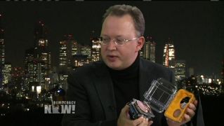
I was offered the job. This is what I showed them. They used a swimming bot* instead.
(Time,July 19, 2017) An underwater robot entered a badly damaged reactor at Japan's Fukushima nuclear plant Wednesday, capturing images of the harsh impact of its meltdown, including key structures that were torn and knocked out of place.
TOKYO, Japan - Images captured by an underwater robot showed massive deposits believed to be melted nuclear fuel covering the floor of a damaged reactor at Japan's [highly contaminated and] crippled Fukushima nuclear plant.
2: lava-like formations underwater (AP)
The robot found large amounts of solidified lava-like rocks and lumps in layers as thick as 3 feet (1 meter) on the bottom inside of a main structure called the pedestal that sits underneath the core inside the primary containment vessel of Fukushima's Unit 3 reactor, said the plant's operator, Tokyo Electric Power Company (TEPCO).
*This is the remote-controlled swimming robot used in the Fukushima operation (Time).
PHOTO 1. Massive deposits believed to be melted nuclear fuel covering the floor of a damaged reactor at Japan's crippled Fukushima nuclear plant in Okuma town, northeastern Japan (International Research Institute for Nuclear Decommissioning/AP).
2. Heaps of solidified lava-like rocks believed to be nuclear fuel that had melted in the 2011 accident during a probe inside of the Unit 3 reactor at Japan's tsunami-wrecked Fukushima nuclear plant.
On Friday (July 21, 2017), the robot spotted suspected debris of melted fuel for the first time since the 2011 earthquake and tsunami caused multiple meltdowns and destroyed the plant. The three-day probe of Unit 3 ended Saturday.
Locating and analyzing the fuel debris and damage in each of the plant's three wrecked reactors is crucial for decommissioning the plant. The search for melted fuel in the two other reactors has so far been unsuccessful because of damage and extremely high radiation levels.
There-there, C3PO. He's scared of Fukushima.
During this week's probe, cameras mounted on the robot showed extensive damage caused by the core meltdown, with fuel debris mixed with broken reactor parts, suggesting the difficult challenges ahead in the decades-long decommissioning of the destroyed plant.
TEPCO spokesman Takahiro Kimoto said it would take time to analyze the debris in the images to figure out debris removal methods. More
(LastWeekTonight with John Oliver, March 2, 2015) America’s crumbling "infrastructure": It’s not a sexy problem, it's a scary one. This is amazing. John Oliver covers the ins and outs of infrastructure. Yes, a million times, yes! I highly recommend watching the entire video. More
.
Water is essential to all existence on our planet
And it is part of a complex and extensive human-made system
Sister Se and Alicia Murphy
Growing up in Los Angeles, I never really thought twice about water. It was always there when I wanted it -- bottled, in the sink, in the yard.
I didn’t know the water I drank was traveling thousands of miles to get to me or even that there was a finite amount of it.
It took a journey all the way to Kenya, Africa for me to understand what water scarcity is and how it feels to have a genuine reverence for this life source.
Thoughts on the Santa Barbara oil spill
Sometimes "bad" and "good" feel really relative [conditional]. But not now, not with this. This is bad, and it will always be bad. I firmly believe that we can develop and implement better forms of energy generation and energy storage. I do not believe that oil will always be Number 1. More
Desalination is often hailed as the savior of the California water crisis. Many people want to know what desalination is all about. Many people think that it is the obvious solution. I think desalination stations warrant a careful discussion because there are so many factors involved that shape their costs and benefits. Here are the… More
Bottled water is still as much of
an as issue now as it was five years ago. It's unfortunate, but it's true. This video does a good job of identifying the
differences and similarities between tap water and bottled water. It
also… More
Titles matter
The Los Angeles Times recently posted an op-ed featuring nine water experts’ opinions on ways to save water. The article is titled “Shorter Showers? Nine more ways the State has to change its ways.” More
When the levy breaks and dam bursts, there goes the city. Then the real drought begins.
Prof. Sherri Mason looks for microbeads in water sample from Lake Michigan.
Legislation to phase out products containing the beads is pending in New Yorkand Illinois (Cheryl Corley).
Erie microbeads (Carolyn Box/AP/5gyres.org)
From the shoreline at North Avenue Beach in Chicago, the blue
water of Lake Michigan stretches as far as the eye can see. But beneath
that pristine image, there's a barely visible threat, says Jennifer
Caddick of the Alliance for the Great Lakes: [toxic plastic debris in the form of] microbeads.
These
tiny bits of plastic, small scrubbing components used in hundreds of
personal care products like skin exfoliants and soap, can slip through
most water treatment systems when they wash down the drain.
Environmentalists
say they're a part of the plastic pollution found in the ocean and,
increasingly, in the Great Lakes, which contain more than 20 percent of
the world's freshwater. Now Illinois and New York state lawmakers are a
step closer to banning them.
Microbeads, says Caddick, engagement director for the Alliance, are "a bigger problem than we initially had thought."
Plastics That Look Like Food
Sherri
Mason, an associate professor of chemistry at the State University of
New York, Fredonia, sailed with a research team over the past couple of
years to collect data on the prevalence of plastics in the lakes. They
dragged a fine mesh net in the waters at half-hour intervals to snag
what they could -- "anything that's bigger than a third of a millimeter,"
Mason says.
When the boat docked at Chicago's Navy Pier last
summer, Mason showed off the sample bottles of microbeads that she and
her team had collected in Lake Michigan.
Mason says her testing
found, on average, 17,000 bits of tiny plastic items per square
kilometer in Lake Michigan. The levels were much lower in Lake Huron and
Lake Superior, but Lake Erie and Lake Ontario had much higher
concentrations. LISTEN
“We can show that the chemicals are adhering to the plastic. We can show that organisms eat the plastic. We can show the chemicals then desorb into the organism that affects the health of THAT organism!” - Associate Prof. of Chemistry Sherri Mason, SUNY, Fredonia
Trillions of plastic microbeads from human
products such as toothpaste are filling up the Great
Lakes and oceans with negative consequences for
marine life and ultimately humans.
TOKYO, Japan - “I write these facts as dispassionately as I can in the hope that they will act as a warning to the world,” wrote the journalist Wilfred Burchett from Hiroshima [site of the atomic bombing by the US].
His story under the headline “The Atomic Plague” appeared in the London Daily Express on Sept. 5, 1945.
Burchett violated the U.S. military blockade of Hiroshima. He was the first Western journalist to visit the devastated city after the bombing. He wrote, “Hiroshima does not look like a bombed city. It looks as if a monster steamroller had passed over it and squashed it out of existence.”
Jump ahead 66 years to March 11, 2011. Six hundred miles north is the Fukushima Nuclear Plant, where the Great East Japan Earthquake [possibly set in motion by the HAARP weapon as the US had previously threatened Japan] caused a tsunami, which led to the nuclear disaster at the nuclear power site. Listen
This
map is from a detailed simulation of the spread of Pacific Ocean
radiation.
It shows the anticipated levels as of August 2013. It may look
scary, but the red color indicates that the levels of Cs137 (cesium/caesium) from
Fukushima are 10,000 times less than when released in March 2011. The light blue indicates levels that are less than one-millionth.
Let’s be clear: The release of radioactive contamination from
the Fukushima Nuclear Power Plant to the environment -- air, land, and sea --
is a massive disaster. There is no other way to describe it.
“Fukushima radiation hits San Francisco! (Dec 2013)”
(Bassfiend/deviantart.com)
Radiation
in the air has spread far and wide. It was even detectable, just barely,
on other continents. Radiation in the ocean is spreading more
slowly but inexorably [with the daily dumping of contaminated water into the Pacific].
Fish caught off Japan
have been too contaminated to be sold for human consumption. And wide expanses of farmland in Japan have been contaminated as well. But
what effects can be expected overseas? What effects can be expected in Hawaii, Alaska, Seattle, California... Boston? More
All materials on this site are submitted by editors and readers. All images, unless otherwise noted, were taken from the Internet and are assumed to be in the public domain.
In the event that there is still a problem, issue, or error with copyrighted material, the break of the copyright is unintentional and noncommercial, and the material will be removed immediately upon presented proof.
Contact us by submitting a comment marked "private."
Do not follow this journal if you are under vinaya or parental restrictions. Secure protection by Sucuri.
Wisdom Quarterly: American Buddhist Journal is licensed under a Creative Commons Attribution-Noncommercial-Share Alike 3.0 United States License. Permissions beyond the scope of this license may be available at creativecommons.org/about/licenses.